Mapping Hiding Places
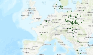
We are using today’s blog to introduce an exciting project called Mapping Hiding Places, in which our committee member Bert Brouwenstijn is involved. This project will map all the hiding places of Jews, Roma and Sinti in The Netherlands (and later on in the project also the rest of Europe) during the Second World War.
Mapping Hiding Places is an international research project that has started with data collection in The Netherlands, by students of the Vrije Universiteit Amsterdam, Faculty of Humanities. The project is initiated by Dr Dienke Hondius of the Vrije Universiteit Amsterdam and it aims to collect information about hiding places in Europe used by Jews, Roma and Sinti trying to escape Nazi persecution during the Holocaust (1933-1945).
The project objective is to increase knowledge and insight into the histories, locations and relations in hiding. The beginning of this research project involves mapping locations that Jews, Roma and Sinti used as hiding places during the occupation. This information is often still kept in the memory of surviving relatives or of survivors, of local eyewitnesses, and in various books, articles, interviews and other sources. Mapping these hiding locations presents an opportunity to gain more insight into the histories, memories, networks, trends and legacies of hiding in Europe during the Holocaust.
The team adhere to three main principles:
- Thorough and precise research
- Respecting privacy and ethical norms
- Openness of our findings
They aim to approach the data from the standpoints of critical cartography, historically accurate storytelling and education.
Do you know of a hiding location / story? Click here:
mappinghidingplaces.org/
mappinghidingplaces.org/


